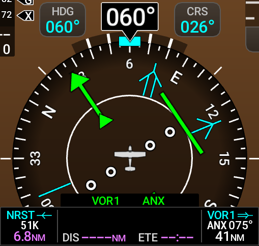
Bearing Pointers and Information Windows
Two bearing pointers and associated information can be displayed on the HSI. When enabled, bearing pointers display the direction of flight required to the selected navigation source. The bearing pointers are light blue and are single-line (Bearing Pointer 1) or double-line (Bearing Pointer 2). The navigation sources available are Flight Plan, VOR (or LOC depending on the radio frequency input), Best Airport (when configured), or Nearest Airport. When the bearing pointer is enabled, an information window with a pointer symbol (1 or 2) appears to indicate the navigation source and is displayed below the HSI containing information about each bearing source. The bearing pointers never override the CDI and are visually separated from the Course Deviation Indicator (CDI) by a white ring (shown when the bearing pointers are selected but not necessarily visible due to data unavailability).
When a bearing pointer is set to indicate Flight Plan information, it will point to the next waypoint in the active flight plan. If no flight plan is active, and the bearing pointer is set to FMS, no bearing pointer will appear on the HSI. If the HSI bearing pointer is set to a radio navigation frequency (e.g., VOR or LOC) it will point in the direction of the source of the signal as long as the station is within range. If the bearing pointer is set to Best, the system will continuously use the configured data (airport length, surface, and distance) as well as the information supplied by the ADAHRS to provide directional information to the best airport to use for an emergency situation. If the bearing pointer is set to Nearest, it will point to the nearest airport to the aircraft. In some circumstances the nearest and best airports are the same location.
When a bearing pointer is displayed, its associated information window is also displayed. The Bearing Information Windows are displayed at the lower sides of the HSI. The following information may be displayed in the Bearing Information Windows:
-
Bearing source (NAV, FMS):
- Flight Plan (FMS)
- VOR
- LOC
- Best (BEST)
- Nearest (NRST)
-
Pointer icon (single lined or double lined)
-
Station / waypoint identifier (NAV, FMS)
- VOR/LOC identifier in green
- VOR direct-to course TO the station
- FMS identifier in magenta
-
GPS-derived great circle distance to bearing source
If a bearing pointer is activated and no NAV or FMS source is available, the information window will only display the Bearing Source (VOR, LOC, or FMS) and dashed lines for the identifier and distance portions of the information window.