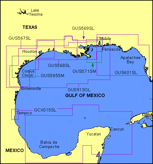
Garmin® Offshore G-Charts in the Gulf of Mexico - Large Charts Region:
Standard G-Charts work with: GPSMAP® 130, 135, 175, 210, 215, 215, 220, 225, 230, and 235.
Micro G-Charts work with: GPSMAP 180 and 185.
For charter/lease or trade-in orders, please call Garmin Cartography Sales at 1-800-800-1020.
| G-Chart |
Micro G-Chart |
Name |
Description |
Datum |
Retail
Price |
GCX015SL
 |
MGCX015SL
|
Mexico East - Yucatan |
Gulf coast of Mexico, Tampico to Cancun |
WGS 84 |
$299 |
GUS567SL
|
MGUS567SL
|
Brownsville - Houston, Aug. 00 |
Brownsville east to Calcasieu Lake including Corpus Chrsit, Sabine Lake and Baffin Bay |
WGS 84 |
$299 |
GUS568SL
|
MGUS568SL
|
Houston - Baton Rouge, Aug. 00 |
Cedar Lakes east to Isles Dernieres including Freeport, Houston/Galveston, Sabine Lake, Calcasieu Lake, Vermilion Bay, Morgan City and Baton Rouge |
WGS 84 |
$299 |
GUS569SL
|
MGUS569SL
|
Baton Rouge - Mobile, Aug. 00 |
Marsh Island east to Mobile Bay including Atchafalaya River, New Orleans, Lake Maurepas, Lake Pontchartrain, Chickasaw Creek, and Tensaw River |
WGS 84 |
$299 |
GUS571SM
|
MGUS571SM
|
Mobile - SW Pass, Aug. 00 |
Mobile Bay west to SW Pass including Brenton Sound, Bay St. Louis, and Biloxi |
WGS 84 |
$199 |
GUS585SM
|
MGUS585SM
|
Cedar Lakes - Baffin Bay, Aug. 00 |
Cedar Lakes west to Baffin Bay including Matagorda Bay, San Antonio Bay and Corpus Christi |
WGS 84 |
$199 |
GUS913GL
|
MGUS913GL
|
Brownsville - Mobile, Aug. 00 |
Cruising chart from Brownsville, TX to Mobile, AL |
WGS 84 |
$299 |
|