|
Garmin's G-Charts
come in two sizes: Standard G-charts or Micro G-charts. Your
Garmin®
chartplotter will accept either the original G-chart or a Micro
G-chart. They are not interchangeable. Please refer to your GPS
plotter manual to determine which size is required. All part numbers
listed designate standard G-charts only. If your plotter requires
a micro G-chart, please add the letter "M" to the beginning of
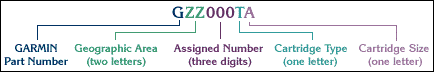
the part number listed. See below for examples. All of our Offshore
G-charts are eight digits in length (nine for Micro G-charts)and
use the following part number format:

| AF=Africa |
ME=Middle
East |
| AS=Asia |
NE=Northern
Europe |
| AT=Atlantic
East |
OC=Oceania |
| CA=Canada |
PL=Ocean
Basins |
| CX=Central
America (Mexico) |
SA=South
America |
| MD=Mediterranean
Sea |
US=United
States |

This can be
any number between 001 and 999.

| S |
Port Services |
Best
range is usually 1nm. Port plans to .25nm or .125nm with Port
Service details |
| X |
Extra Detailed |
Best
range is usually 1nm with port plans to .25nm or .125nm |
| D |
Detailed |
Best
range is usually 2nm with port plans to .25nm or .125nm |
| F |
Fishing |
Best
range is usually 2nm. Extended depth contours, bottom conditions,
and fishing information. May have port plans to .25nm or .125nm |
| G |
General |
Best
range is usually 2nm or 4nm. May have port plans to .25nm
or .125nm |
| C |
Coastal |
Best
general is usually 1nm or 2nm. No port plans. 1:100,000 to
1:40,000 scale charts |

| S |
Small
($99.00) |
| M |
Medium
($199.00) |
| L |
Large
($299.00) |
Standard
G-chart Examples:
| GUS124XL |
San Juan
Islands to Puget Sound (United States) |
| GSA012DM |
Colombia
(South America) |
| GNE074DS |
Normandy
(France) |
Micro G-chart Examples:
| MGUS124XL |
San Juan
Islands to Puget Sound (United States) |
| MGSA012DM |
Colombia
(South America) |
| MGNE074DS |
Normandy
(France) |
|