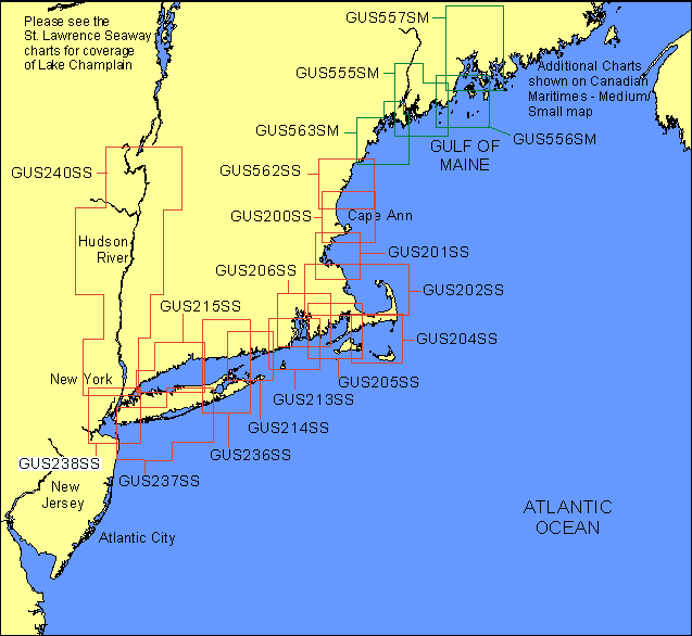
Garmin® Offshore G-Charts in the Northeast Coast - Medium/Small Charts Region:
Standard G-Charts work with: GPSMAP® 130, 135, 175, 210, 215, 215, 220, 225, 230, and 235.
Micro G-Charts work with: GPSMAP 180 and 185.
For charter/lease or trade-in orders, please call Garmin Cartography Sales at 1-800-800-1020.
| G-Chart |
Micro G-Chart |
Name |
Description |
Datum |
Retail
Price |
GUS200SS
 |
MGUS200SS
|
Cape Ann & Appr |
Hampton Harbor to Salem Harbor |
WGS 84 |
$99 |
GUS201SS
|
MGUS201SS
|
Massachusetts Bay |
Salem to Green Harbor, including Massachusetts Bay and Boston Harbor |
WGS 84 |
$99 |
GUS202SS
|
MGUS202SS
|
Plymouth & Approaches |
Scituate to Provincetown, including Cape Cod Bay and north shore of Cape Cod |
WGS 84 |
$99 |
GUS204SS
|
MGUS204SS
|
Hyannis - Nantucket Island |
Chatham to Hyannis, including entire Nantucket Island and eastern portion of Martha's Vineyard |
WGS 84 |
$99 |
GUS205SS
|
MGUS205SS
|
Buzzards Bay |
Westport Point to Woods Hole, including entire Buzzards Bay and Martha's Vineyard |
WGS 84 |
$99 |
GUS206SS
|
MGUS206SS
|
Narragansett Bay |
Fairhaven to Point Judith, including entire Narragansett Bay |
WGS 84 |
$99 |
GUS213SS
|
MGUS213SS
|
Block Island |
Newport to Block Island |
WGS 84 |
$99 |
GUS214SS
|
MGUS214SS
|
Gardiners Bay |
Mystic to Old Saybrook, south to Shelter Island to Montauk |
WGS 84 |
$99 |
GUS215SS
|
MGUS215SS
|
New Haven to City Island |
New Haven to City Island, including north shore of Long Island to Port Jefferson |
WGS 84 |
$99 |
GUS236SS
|
MGUS236SS
|
Essex - Shinnecock |
New London to Westbrook, south to Shinnecock |
WGS 84 |
$99 |
GUS237SS
|
MGUS237SS
|
Long Island South |
Westhampton to Jamaica Bay |
WGS 84 |
$99 |
GUS238SS
|
MGUS238SS
|
New York Harbor |
City Island to Sandy Hook |
WGS 84 |
$99 |
GUS240SS
|
MGUS240SS
|
Hudson River |
Lake George to Tarrytown. Entire Lake George and Hudson River |
WGS 84 |
$99 |
GUS555SM
|
MGUS555SM
|
Kennebec River, Mar. 00 |
Sebascodegam Island to St George River Entrance Including Cape Small, Muscongus Bay and entire Kennebec River |
WGS 84 |
$199 |
GUS556SM
|
MGUS556SM
|
SW Appr to Penobscot Bay, Mar. 00 |
St George River to Deer Isle Including Matinicus Island and Monhegan Island |
WGS 84 |
$199 |
GUS557SM
|
MGUS557SM
|
Penobscot River, Mar. 00 |
Bangor to Rockport Harbor Including northern Penobscot Rvier, Belfast, Camden, Deer Isle, Blue Hill Harbor and Casco Passage |
WGS 84 |
$199 |
GUS562SS
|
MGUS562SS
|
Portsmouth, Mar. 00 |
Hampton Harbor to Cape Porpoise Harbor Including Wells Harbor, Kennebunk River |
WGS 84 |
$99 |
GUS563SM
|
MGUS563SM
|
Portland, Mar. 00 |
Kennebunk River to Cape Small Including Portland, Brunswick and New Meadows |
WGS 84 |
$199 |
|