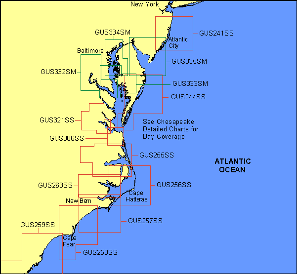
Garmin® Offshore G-Charts in the Mid-East Coast - Medium/Small Charts Region:
Standard G-Charts work with: GPSMAP® 130, 135, 175, 210, 215, 215, 220, 225, 230, and 235.
Micro G-Charts work with: GPSMAP 180 and 185.
For charter/lease or trade-in orders, please call Garmin Cartography Sales at 1-800-800-1020.
| G-Chart |
Micro G-Chart |
Name |
Description |
Datum |
Retail
Price |
GUS068SS
 |
MGUS068SS
|
Bermuda Islands |
Bermuda Islands |
WGS 84 |
$99 |
GUS241SS
|
MGUS241SS
|
Rumson - Atlantic City |
Shark River Inlet to Atlantic City |
WGS 84 |
$99 |
GUS244SS
|
MGUS244SS
|
Ocean City - Cape Charles |
Ocean City to Cape Charles |
WGS 84 |
$99 |
GUS255SS
|
MGUS255SS
|
Albemarle Sound |
Elizabeth City to Hatteras Island, including all Albemarle Sound |
WGS 84 |
$99 |
GUS256SS
|
MGUS256SS
|
Cape Hatteras |
Roanoke Island to Ocracoke |
WGS 84 |
$99 |
GUS257SS
|
MGUS257SS
|
Morehead City & Approaches |
Ocracoke to Morehead City, including Cape Lookout |
WGS 84 |
$99 |
GUS258SS
|
MGUS258SS
|
Cape Fear & Approaches |
Browns Inlet to Cape Fear |
WGS 84 |
$99 |
GUS259SS
|
MGUS259SS
|
Little River - Georgetown |
Little River Inlet to Cape Romain |
WGS 84 |
$99 |
GUS263SS
|
MGUS263SS
|
Pamlico River |
Swanquarter to Washington |
WGS 84 |
$99 |
GUS306SS
|
MGUS306SS
|
Norfolk & Approaches, May 99 |
Batten Bay to Back Bay including Hampton |
WGS 84 |
$99 |
GUS321SS
|
MGUS321SS
|
James & York Rivers, May 99 |
Batten Bay to Richmond including the entire James and York Rivers |
WGS 84 |
$99 |
GUS332SM
|
MGUS332SM
|
Potomac River, Mar. 00 |
Potomac River to Washington DC including Yeocomico River, St Mary's River, Nonimi Creek, St. Clements Bay, Potomac Creed, Mattawoman Creek and Port Tobacco |
WGS 84 |
$199 |
GUS333SM
|
MGUS333SM
|
Pt. Lookout - Eastern Bay, Mar. 00 |
Point Lookout to Eastern Bay, including Patuxent River, Nanticoke River, St Marys River, Wicomico River and Manokin River |
WGS 84 |
$199 |
GUS334SM
|
MGUS334SM
|
Upper Chesapeake Bay, Mar. 00 |
Furnace Bay to Choptank River, including Baltimore, Annapolis and Eastern Bay |
WGS 84 |
$199 |
GUS335SM
|
MGUS335SM
|
Delaware Bay, Mar. 00 |
Rehoboth Bay to Great Bay, including Delaware Bay, Great Harbor River, Cape May, Maurice River and Cape Henlopen |
WGS 84 |
$199 |
|