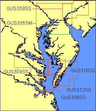
Garmin® Offshore G-Charts in the Chesapeake Bay Detailed Region:
Standard G-Charts work with: GPSMAP® 130, 135, 175, 210, 215, 215, 220, 225, 230, and 235.
Micro G-Charts work with: GPSMAP 180 and 185.
For charter/lease or trade-in orders, please call Garmin Cartography Sales at 1-800-800-1020.
| G-Chart |
Micro G-Chart |
Name |
Description |
Datum |
Retail
Price |
GUS308SS
 |
MGUS308SS
|
Mobjack Bay, May 99 |
Piankatank River to Hampton including Fishermans Island, Cape Charles, Old Castle Creek, Church Neck and Waterhouse Creek |
WGS 84 |
$99 |
GUS309SS
|
MGUS309SS
|
Rappahannock River, May 99 |
Dahlgren to Stingray Pt including Urbanna, Corrotoman River, Dymer Cr, Indian Cr, Little Wicomico River, Point Lookout |
WGS 84 |
$99 |
GUS310SS
|
MGUS310SS
|
Pocomoke River - Tangier Island, May 99 |
Big Annemessex River to Curratuck Creek including Smith Island & Tangier Island |
WGS 84 |
$99 |
GUS312SS
|
MGUS312SS
|
Cape Charles Approaches, May 99 |
Chincoteqague Inlet to Cape Charles including Fishermans Island, Smith Island, Myrtle Island, Cobb Island, Hog Island Parramore Island |
WGS 84 |
$99 |
GUS336SM
|
MGUS336SM
|
Baltimore - Wilmington, Mar. 00 |
Rock Hall Harbor to Chester, including Leipsic River, Canton, C&D Canal, Mannington Creek, Sassafras River and Chester River |
WGS 84 |
$199 |
GUS339SS
|
MGUS339SS
|
Delaware River, Mar. 00 |
Wilmington to Trenton including the entire Delaware River |
WGS 84 |
$99 |
|