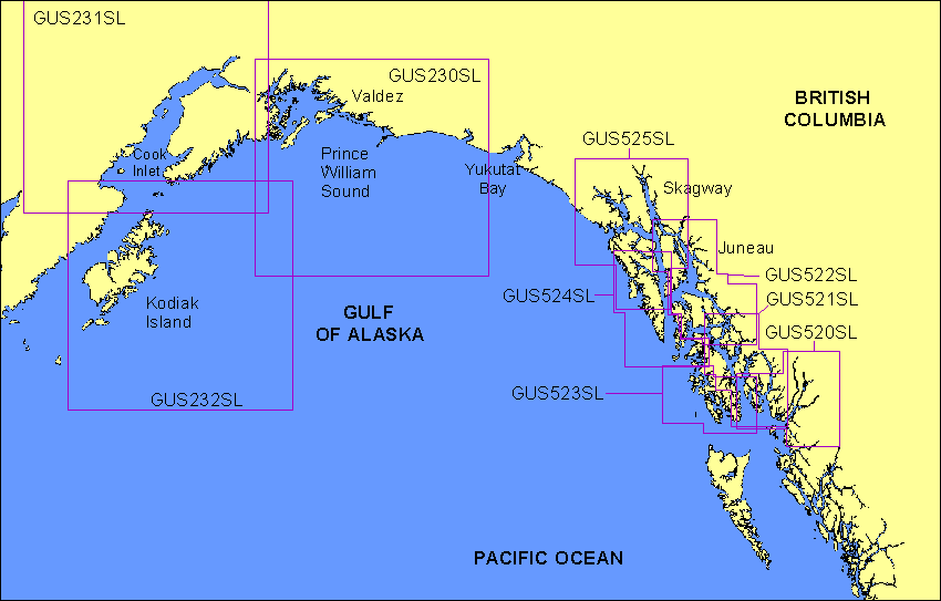
Garmin® Offshore G-Charts in the Gulf of Alaska - Large Charts Region:
Standard G-Charts work with: GPSMAP® 130, 135, 175, 210, 215, 215, 220, 225, 230, and 235.
Micro G-Charts work with: GPSMAP 180 and 185.
For charter/lease or trade-in orders, please call Garmin Cartography Sales at 1-800-800-1020.
| G-Chart |
Micro G-Chart |
Name |
Description |
Datum |
Retail
Price |
GUS230SL
 |
MGUS230SL
 |
Prince William Sound |
From Johnstone Bay to Cape Sikagi, including Icy Bay, Prince William Sound and Montague Island |
WGS 84 |
$299 |
GUS231SL
 |
MGUS231SL
 |
Cook Inlet |
Entire Cook Inlet |
WGS 84 |
$299 |
GUS232SL
 |
MGUS232SL
 |
Kodiak & Afognak Islands |
Including Kodiak and Afognak Islands entirely |
WGS 84 |
$299 |
GUS520SL
 |
MGUS520SL
 |
Portland Canal - Ketchikan, Mar. 00 |
Portland Canal to Cape Chacon Including Duke Island, Ketchikan, North Dundas Island, Portland Inlet and Tree Point |
WGS 84 |
$299 |
GUS521SL
 |
MGUS521SL
 |
Clarence Strait, Mar. 00 |
Wrangell to Main Passage Including Zarembo Island, Clarence Strait, Ketchikan, Wrangell Island, Eastern Passage, Behm Canal, Revillagigedo Channel and Cape Chacon |
WGS 84 |
$299 |
GUS522SL
 |
MGUS522SL
 |
Juneau to Wrangell, Mar. 00 |
Juneau to Wrangell Including Wrangell Island, Frederick Sound, Kupreanof Island, Seymour Channel, Tracy Arm, Stephens Passage, Taku Inlet, Mansfield Peninsula, Freshwater Bay and Sitkoh Bay |
WGS 84 |
$299 |
GUS523SL
 |
MGUS523SL
 |
Noyes I - Ketchikan, Mar. 00 |
Noyes Island to Ketchikan Including Cape Bartolome, Dall Island, Cordova Bay, Cape Chacon and Skowl Arm |
WGS 84 |
$299 |
GUS524SL
 |
MGUS524SL
 |
Chatham Strait, Mar. 00 |
Cape Edward to Coronation Island Including Peril Strait, Salisbury Sound, Sitka Sound, Baranof Island, Point Gardner, The Bay of Pillars and El Capitan Passage |
WGS 84 |
$299 |
GUS525SL
 |
MGUS525SL
 |
Glacier Bay - Sitka Sd, Mar. 00 |
Glacier Bay to Sitka Sound Including Lituya Bay, Lynn Canal, Cross Sound, Icy Strait, Chatham Strait, Chichagof Island, Cape Edward and Salisbury Sound |
WGS 84 |
$299 |
|