Garmin® Offshore G-Charts in the Alaska Southwest - Large Charts Region:
Standard G-Charts work with: GPSMAP® 130, 135, 175, 210, 215, 215, 220, 225, 230, and 235.
Micro G-Charts work with: GPSMAP 180 and 185.
For charter/lease or trade-in orders, please call Garmin Cartography Sales at 1-800-800-1020.
| G-Chart |
Micro G-Chart |
Name |
Description |
Datum |
Retail
Price |
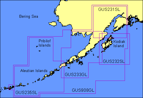
GUS231SL
 |
MGUS231SL
|
Cook Inlet |
Entire Cook Inlet |
WGS 84 |
$299 |
GUS232SL
|
MGUS232SL
|
Kodiak & Afognak Islands |
Including Kodiak and Afognak Islands entirely |
WGS 84 |
$299 |
GUS233SL
|
MGUS233SL
|
Bristol Bay - Alaska Peninsula |
From Katmai Bay to Cape Newenham, including Bristol Bay and entire Alaska Peninsula |
WGS 84 |
$299 |
GUS235SL
|
MGUS235SL
|
Aleutian Islands |
From Unimak Pass to Tanaga Island, including Pribilof Islands |
WGS 84 |
$299 |
GUS908GL
|
MGUS908GL
|
Aleutians - Cook Inlet |
From Anchorage to Tanaga Island, including Kodiak Island, Alaska Peninsula and Andreanof Island |
WGS 84 |
$299 |
|