Relative Terrain Symbology
The terrain system uses colors and symbols to represent terrain and point obstacles (with heights greater than 200 feet above ground level, AGL) present in the databases relative to aircraft altitude. The system dynamically adjusts these colors as the aircraft altitude changes, and after takeoff and landing.
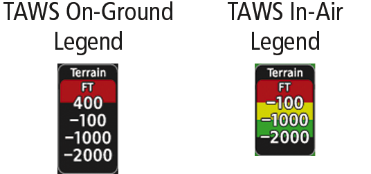
While the aircraft is on the ground, the system displays relative terrain 400 feet or more above the aircraft altitude using red, and terrain at less than 400 feet above aircraft altitude using black, as shown on the On- Ground Legend. When the aircraft is in the air, the system displays relative terrain information using red, yellow, green, and black, as shown on the In-Air Legend. As the aircraft transitions from on-ground to in-air, or from in-air to on-ground, the display of relative terrain momentarily fades into the corresponding colors. If an alert occurs, the relative terrain colors transition to the In-Air Legend if the On-Ground Legend was shown in order to provide the pilot with the most information possible.
The following figure shows relative terrain coloring for TAWS. Warnings, depicted in red, indicate the aircrafts height above the obstacle is within 100 feet. Cautions, depicted in yellow, indicate the aircrafts height above the obstacle is within 1000 feet (305 meters). White obstacles indicate the aircraft is more than 1000 feet above the obstacle.
With Adaptive Terrain enabled, the caution alerts and indications can be configured to announce at or below 500, 750, or 1000 feet.

|
Unlighted Obstacle |
Lighted Obstacle |
Obstacle Location |
||
|---|---|---|---|---|
|
< 1000' AGL |
> 1000'AGL |
< 1000' AGL |
> 1000'AGL |
|
 |
 |
 |
 |
Red obstacle is above or within 100 ft below the aircraft altitude. |

|
 |
 |
 |
Yellow obstacle is between 100 ft and 1000 ft below the aircraft altitude.1 |
 |
 |
 |
 |
White obstacle is more than 1000 ft below aircraft altitude. |
|
1 With Adaptive Terrain enabled, the caution alerts and indications can be configured to announce at or below 500, 750, or 1000 feet. |
||||
|
Wire Obstacle |
Wire Obstacle Location |
|---|---|
 |
Red wire obstacle is at or above the aircraft altitude. |
 |
Yellow obstacle is between 100 ft and 250 ft below the aircraft altitude. |
 |
White wire obstacle is more than 250 ft below the aircraft altitude. |
|
Unlighted Wind Turbine Obstacle |
Lighted Wind Turbine Obstacle |
Wind Turbine Obstacle Location |
|---|---|---|
 |
 |
Red obstacle is above or within 100 ft below the aircraft altitude. |
 |
 |
Yellow obstacle is between 100 ft and 1000 ft below the aircraft altitude.1 |
 |
 |
White obstacle is more than 1000 ft below aircraft altitude. |
|
1 With Adaptive Terrain enabled, the caution alerts and indications can be configured to announce at or below 500, 750, or 1000 feet. |
||
TAWS will show potential impacts areas for terrain and obstacles as shown in the following table.
|
Potential Impact Area Example |
Alert Type |
Example Annunciation |
||
|---|---|---|---|---|
 |
or |  |
Warning |
 |
 |
or |  |
Caution |
 |