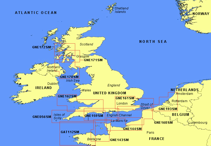
Garmin® Offshore G-Charts in the U.K. / Ireland / English Channel - Medium Charts Region:
Standard G-Charts work with: GPSMAP® 130, 135, 175, 210, 215, 215, 220, 225, 230, and 235.
Micro G-Charts work with: GPSMAP 180 and 185.
For charter/lease or trade-in orders, please call Garmin Cartography Sales at 1-800-800-1020.
| G-Chart |
Micro G-Chart |
Name |
Description |
Datum |
Retail
Price |
GAT112SM
|
MGAT112SM
|
Portrieux/Pouldu, May 99 |
Binic to Port De Pouldu, Ile De Brehat, Les Septeiles, Ile De Batz, Ile D'Ouessant, Ile Molene, Ile De Sien |
WGS 84 |
$199 |
GNE056SM
 |
MGNE056SM
 |
England S/W, Aug. 97 |
Scilly Island to Poole Bay |
WGS 84 |
$199 |
GNE143SM
 |
MGNE143SM
 |
Channel I/St. Malo, May 99 |
Cherbourg to Paimpol, Channel Islands (Alderney I., Guernsey I., Jersey I.), Grand Ile. |
WGS 84 |
$199 |
GNE144SM
 |
MGNE144SM
 |
Cherbourg/Le Treport, Apr. 98 |
Cherbourg/Le Treport |
WGS 84 |
$199 |
GNE159SM
 |
MGNE159SM
 |
England South, Dec. 97 |
Start Point to Littlehamption, Isle of Wight |
WGS 84 |
$199 |
GNE160SM
 |
MGNE160SM
 |
English Channel East, Aug. 97 |
Dover to Littlehampton, Dunkerque to Fecamp |
WGS 84 |
$199 |
GNE161SM
|
MGNE161SM
|
Thames/Dunkerque, Aug. 97 |
Felixstowe to River Thames; Dover to Dunkerque |
WGS 84 |
$199 |
GNE162SM
 |
MGNE162SM
 |
Bristol Channel, Aug. 97 |
Aberporth to Bideford, Ramsey I., Skomer I., Lundy I. |
WGS 84 |
$199 |
GNE170SM
 |
MGNE170SM
 |
Irish Sea North Channel, Aug. 97 |
Ballycastle to Kilkeel, Campbeltown to Drummore Bay, Isle of Man |
WGS 84 |
$199 |
GNE171SM
 |
MGNE171SM
 |
Scotland S/W Inner, Aug. 97 |
Oban to Campbeltown, Jura, Island of Arran |
WGS 84 |
$199 |
GNE172SM
 |
MGNE172SM
 |
Scotland West Inner, Sep. 97 |
Mallaig to Crinan Harbour |
WGS 84 |
$199 |
GNE193SM
|
MGNE193SM
|
Dunkkerque / Rotterdam, Nov. 97 |
Ijmuiden to Dunkerque |
WGS 84 |
$199 |
|