|
|
| Inland
G-Chart® Details |
| Using
Garmin® Inland G-Chart |
|
Each Inland
G-chart cartridge covers all or part of an entire state with an
accuracy to 160 feet. States with detailed information that exceeds
a chart's memory capacity are divided into regions, while smaller
states may be combined to provide the best value in a single cartridge.
Once an Inland G-chart is loaded into your Garmin GPSMAP® unit,
a coverage outline of the overall area covered will appear on
the unit's map page., indicating the highest level of detailed
coverage (usually 512, 256, or 128 nm range). Inside the main
coverage box, smaller map outlines are used to indicate where
detailed coverage is available.
As you zoom
in to the scale where detailed coverage begins, the freeways and
national/state highways covered on the cartridge will begin to
appear, as well as lakes and reservoirs large enough to show up
at the selected map scale. As you continue to zoom in on a detailed
coverage area, smaller lakes and reservoirs will begin to appear,
with boat ramps, marinas, and other items usually appearing at
the 16 nm scale. Remember, due to space limitations and to eliminate
screen clutter, all items may not appear until you have reached
a smaller map scale. It is also important that you check the map
configuration settings of your GPSMAP unit to ensure that a specific
map feature has been selected to appear at the desired map scale.
|
| Road
Coverage |
|
Freeways/Interstates
will begin to appear at the highest level of coverage (512, 256,
or 128 nm) for the covered state down to the 8 nm (in areas without
detailed coverage) or 1 nm scale (in areas with detailed coverage).
Freeway text will appear at the same scales.
National
highways
will begin to appear at the highest level of coverage (512, 256,
or 128 nm) for the covered state down to the 8 nm (in areas without
detailed coverage) or 1 nm scale (in areas with detailed coverage).
Highway text will appear at the same scales.
State
highways
will begin to appear at the highest level of coverage (512, 256,
or 128 nm) for the covered state down to the 8 nm (in areas without
detailed coverage) or 1 nm scale (in areas with detailed coverage).
State highway text will appear at the 64 nm scale and below.
Local/County
Roads
will only appear in areas of detailed coverage beginning at the
4 nm scale, down to the 1 nm scale. Only county and local roads
in close proximity to inland waters will be shown. Text for these
items will appear at the same scales.
|
| Lake
Coverage |
| Lakes and reservoirs
covered in detail will begin to appear at the highest level of coverage
(512, 256, or 128 nm) for the state down to the 1 nm scale. View
Inland Charts. |
| River
Coverage |
| The emphasis
of Inland G-charts is on the inland lakes and reservoirs. Because
of the constant change in course and shoreline, major rivers will
only be shown down to an 8 nm scale. Waterways connecting inland
bodies of water will usually be covered down to the 1 nm scale. |
| Text
Names |
| The text names
of bordering states, bodies of water, cities, and other items will
appear at different levels based on the size, complexity, and space
availability of the map. In general, text for larger lakes, reservoirs,
and cities will appear at the higher map scales, with additional
text information becoming available at the lower map scales. The
display of any text name will also be limited by the current setting
selected from the map configuration menu of the GPSMAP unit. |
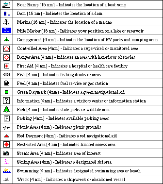
| Symbols |
| In addition
to providing shoreline and highway information, Inland G-charts
display boat ramps, marinas, campgrounds, dams, public facilities,
and other items of interest for covered lakes and reservoirs.
Note: The
number in parentheses indicates the highest zoom level at which
the symbol appears.
|
|
| User
Symbols |
| One of the
great advantages of Inland G-charts is the ability to add your own
points of interest using your Garmin GPSMAP unit. These user waypoints
can be used to mark a new boat ramp, a marina, or your very own
fishing hotspots. These waypoints are stored in the unit's memory
and may be configured to show up at the map scale of your choice.
With more than 30 symbols to choose from, you can create a cruising
guide for your entire state.
Note: Inland
Cartography is Not Intended for Navigational Purposes.
For more information,
please contact a Garmin Cartography Representative at [email protected]
|
|