Garmin® Offshore G-Charts in the Northeast Coast - Large Charts Region:
Standard G-Charts work with: GPSMAP® 130, 135, 175, 210, 215, 215, 220, 225, 230, and 235.
Micro G-Charts work with: GPSMAP 180 and 185.
For charter/lease or trade-in orders, please call Garmin Cartography Sales at 1-800-800-1020.
| G-Chart |
Micro G-Chart |
Name |
Description |
Datum |
Retail
Price |
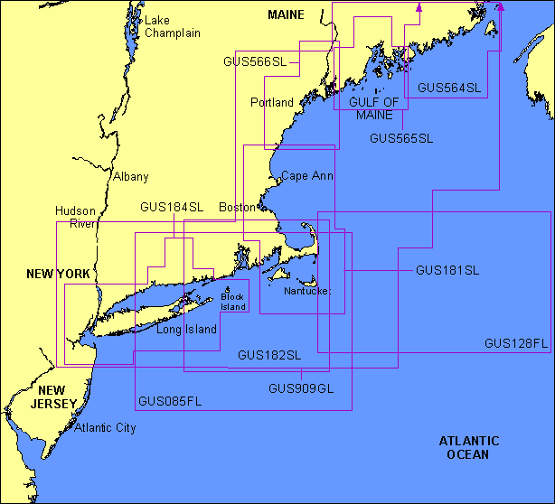
GUS085FL
 |
MGUS085FL
|
North Atlantic Canyons |
Nauset Harbor, Cape Cod to Bellport Bay, Long Island; including offshore fishing information from Gilbert Canyon to Carteret Canyon |
NAD 27 |
$299 |
GUS128FL
|
MGUS128FL
|
Georges Bank |
Includes entire Georges Bank, east to Great South Channel and Davis Bank |
WGS 84 |
$299 |
GUS181SL
|
MGUS181SL
|
Cape Cod & Approaches |
From Hampton Harbor to Cuttyhunk Island, including Cape Cod and the Islands |
WGS 84 |
$299 |
GUS182SL
|
MGUS182SL
|
Cape Cod - Montauk |
From Plymouth to Montauk, including Cape Cod, the Islands, Narragansett Bay and Block Island |
WGS 84 |
$299 |
GUS184SL
|
MGUS184SL
|
New York to Block Island |
From New York Harbor to Block Island including all of Long Island and Long Island Sound |
WGS 84 |
$299 |
GUS564SL
|
MGUS564SL
|
Down East Maine, Mar. 00 |
Blue Hill Bay to Beaver Harbor Including Frenchman Bay, Harrington River, Machias River, Deer Island, Passamaquoddy Bay and Campobello Island |
WGS 84 |
$299 |
GUS565SL
|
MGUS565SL
|
Penobscot Bay, Mar. 00 |
Muscongus Bay to Winter Harbor Including Blue Hill Harbor, Fox Island Thorofare, Rockport, Bar Harbor, Deer I Thorofare, Casco Passage, Camden, Belfast and the Penobscot River |
WGS 84 |
$299 |
GUS566SL
|
MGUS566SL
|
Hampton - Augusta, Mar. 00 |
Hampton Harbor to Johns Bay including the entire Kennebec River |
WGS 84 |
$299 |
GUS909GL
|
MGUS909GL
|
Maine - New York, Jun 00 |
Grand Manan Island to Shark River. Including Long Island, Block Island, Nantucket and Martha's Vineyard |
WGS 84 |
$299 |
|