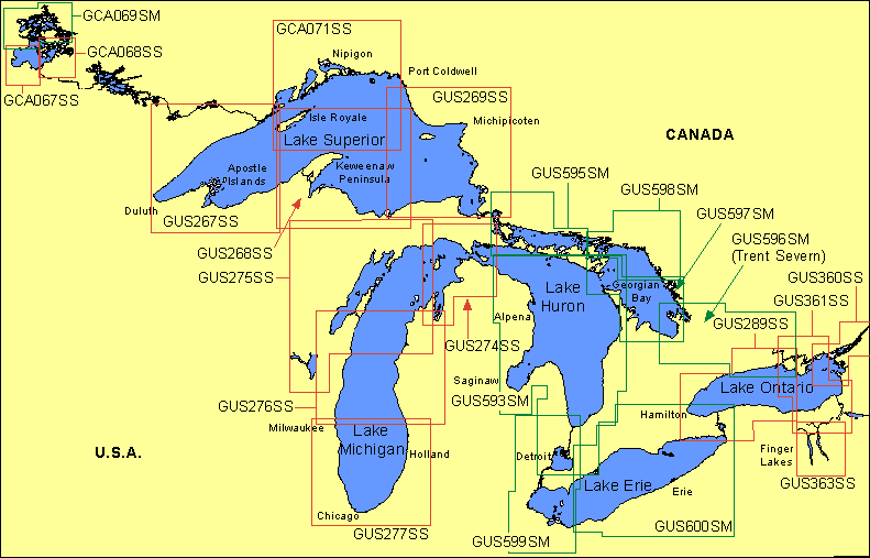
Garmin® Offshore G-Charts in the Great Lakes - Medium / Small Charts Region:
Standard G-Charts work with: GPSMAP® 130, 135, 175, 210, 215, 215, 220, 225, 230, and 235.
Micro G-Charts work with: GPSMAP 180 and 185.
For charter/lease or trade-in orders, please call Garmin Cartography Sales at 1-800-800-1020.
| G-Chart |
Micro G-Chart |
Name |
Description |
Datum |
Retail
Price |
GCA067SS
 |
MGCA067SS
|
Lake of the Woods S/W |
Lake of the Woods southwest, Northwest Angle to Rainy River |
WGS 84 |
$99 |
GCA068SS
|
MGCA068SS
|
Lake of the Woods S/E |
Lake of the Woods southeast, Bigsby Island to Sioux Narrows |
WGS 84 |
$99 |
GCA069SM
|
MGCA069SM
|
Lake of the Woods North |
Lake of the Woods north, Throat Rapids to Whitefish Narrows, east to Clearwater Bay |
WGS 84 |
$199 |
GCA071SS
|
MGCA071SS
|
Lake Superior North |
Thunder Bay to Heron Bay |
WGS 84 |
$99 |
GUS267SS
|
MGUS267SS
|
Duluth & Superior |
Grand Marais south to Duluth, west to Ontonagon |
WGS 84 |
$99 |
GUS268SS
|
MGUS268SS
|
Lake Superior South |
Keweenaw Peninsula to Munising |
WGS 84 |
$99 |
GUS269SS
|
MGUS269SS
|
Lake Superior S/E |
Munising west to Sault Ste. Marie, north to Michipicoten Island |
WGS 84 |
$99 |
GUS274SS
|
MGUS274SS
|
Straits of Mackinac |
Hessel to Traverse City |
WGS 84 |
$99 |
GUS275SS
|
MGUS275SS
|
Green Bay |
Detroit Harbor to Oshkosh |
WGS 84 |
$99 |
GUS276SS
|
MGUS276SS
|
Mid Lake Michigan |
Algoma to Holland |
WGS 84 |
$99 |
GUS277SS
|
MGUS277SS
|
Lake Michigan South |
Port Washington to White Lake |
WGS 84 |
$99 |
GUS289SS
|
MGUS289SS
|
Lake Ontario West |
Buffalo to Rochester, includes Toronto to Belleville |
WGS 84 |
$99 |
GUS360SS
|
MGUS360SS
|
Thousand I & Approaches |
Ogdensburg to Sackets Harbor |
WGS 84 |
$99 |
GUS361SS
|
MGUS361SS
|
Lake Ontario N/E |
Trent River to Sodus Bay |
WGS 84 |
$99 |
GUS363SS
|
MGUS363SS
|
Finger Lakes |
Seneca & Cayuga Lakes |
WGS 84 |
$99 |
GUS593SM
|
MGUS593SM
|
Lake Huron, Aug. 00 |
Hammond Bay, Roger City east to Great Duck Island, east through Main Channel into Georgian Bay and south to Detroit including Lake St. Clair |
WGS 84 |
$199 |
GUS595SM
|
MGUS595SM
|
North Channel, Aug. 00 |
St. Mary's River / Sugar Island to West Bay including western Lake Manitou and west to Martin Reef |
WGS 84 |
$199 |
GUS596SM
|
MGUS596SM
|
L. Simcoe - Trent Severn, Aug. 00 |
Western Island Light, Twelve Mile Bay, Lake Simcoe, Trent Severn to Bay of Quinte to Cobourg |
WGS 84 |
$199 |
GUS597SM
|
MGUS597SM
|
South Georgian Bay, Aug. 00 |
South Baymouth and Owen Channel / Main Channel to Parry Sound including Parry Sound Harbour and south to Collingwood |
WGS 84 |
$199 |
GUS598SM
|
MGUS598SM
|
North Georgian Bay, Aug. 00 |
Little Current and the entrance to North Channel, southeast to Shawanaga Inlet and Point au Baril |
WGS 84 |
$199 |
GUS599SM
|
MGUS599SM
|
Lake Erie West, Aug. 00 |
Port Huron south to Toledo and east to Huron/Vermillion including Pelee Passage, South Passage, Put-in-Bay, Detroit River and Lake St. Clair |
WGS 84 |
$199 |
GUS600SM
|
MGUS600SM
|
Lake Erie East, Aug. 00 |
Buffalo to Cleveland / Rondeau Harbour including Hamilton, Youngstown, Welland Canal and Niagara River |
WGS 84 |
$199 |
|